Our Texas history resources for grade 4 and grade 7 are designed to inspire deep interaction with content while aligning with standards in your state.
Free Lesson
Texas Studies Cotton, Cattle, and Railroads Teach students about the evolution of cattle, cotton, and railroads, including boom and bust cycles, and the beginning of urbanization in Texas.
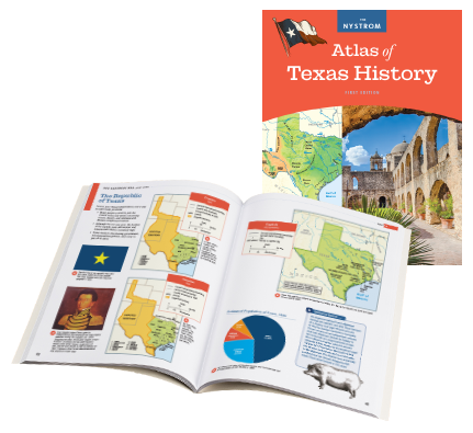
Discover all the geographic history Texas has to offer in this beautifully illustrated atlas. Students will be able to uncover historical facts from the first inhabitants of Texas, as well as learn about the diversity of modern Texas.
Notable Content:
An easy to understand “Using This Atlas ” guide
Notable Texans excerpts give a spotlight to those who played major roles in history
Land maps showcase geographic diversity
Understand the conflicts between the different groups that settled in Texas
The Modern Texas Unit covers what living in Texas is like today
Mapping Texas History
Mapping Texas History has flexibility built in. Use the program as a foundation or customize it to fit your curriculum.
Your students will discover relationships and patterns between the people and places of Texas history by building a chronological foundation of key events, looking for causes and effects, and analyzing maps, graphs, photos, and text.
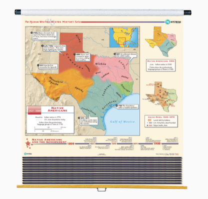
Texas History Map
Texas History Map
12-Map set
Provide a deeper look into key events in Texas and U.S. history with 12 wall maps, mounted on a roller:
Native Americans in Texas
Spanish Explorers
Spanish Settlements
Republic of Texas
War With Mexico; 1846–1848
American Expansion
Slavery and the Economy; 1860
The Union and the Confederacy
Indian Wars; 1622–1890
Railroads Transform the West
Great Depression and Dust Bowl
Texas Energy Resources
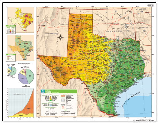
Desk Maps
map set (NYS3442)
Facilitate hands-on mapping activities with markable desk maps showing county boundaries, geographical features, capitals, city populations, and more. These match our Texas wall map so students can follow along while the teacher works at the front of the class.
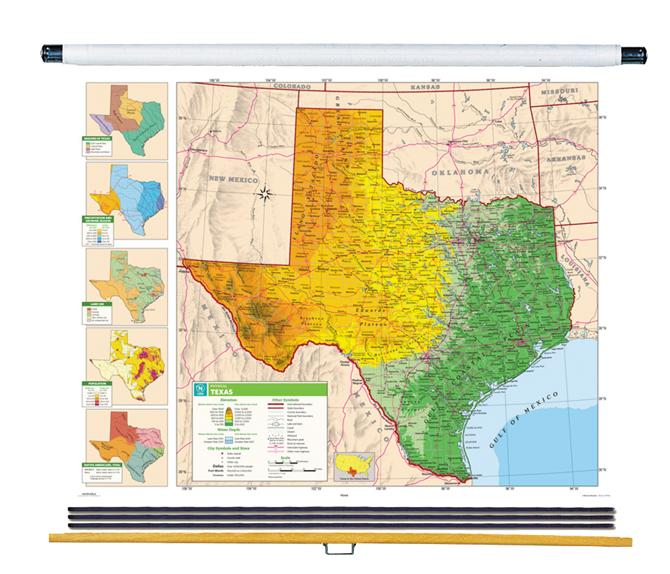
Texas/U.S./World Map Set
Give students a visual understanding of Texas county boundaries, geographical features, capitals, and city populations. These colorful, easy to use, and well-organized wall maps are mounted on a spring roller for quick access.
Texas Studies 4th Grade
Readings and correlated activities that engage every learning style turn fourth grade students into Lone Star scholars. Includes a student reader and teacher’s guide with reproducible handouts. Also available in Spanish.
Texas Studies 7th Grade Active Classroom License
Go digital with our easy-to-use platform that allows students to explore Texas social studies. This newly redesigned program provides activities that differentiate while providing practice in skills that address state standards.
Meet Your State Curriculum Specialists
Jason Ihlenfeld
Texas curriculum specialist
jason@socialstudies.com
800-421-4246 x293
I had spectacular teachers who inspired me to focus my college years in the Social Sciences, finishing a B.A. in History, and minors in Political Science, Sociology, and Business. I spent eight years as a social studies classroom teacher.
Summer Carter
Texas curriculum specialist
summer@socialstudies.com
800-421-4246 x292
Social studies has always been my passion. After graduating from Texas Christian University with a B.S. in Education focusing on secondary social studies, I taught high school economics and world history.
Enhance the Classroom
Contact your curriculum specialist about bringing these exciting maps and globes into your school!
Elementary
Maps: Primary: ELS
Maps: Primary: Readiness
Maps: Primary: Outline World Map
Maps: Intermediate: Physical
Maps: Intermediate: Political
Maps: Intermediate: Continents and Oceans Thematic
Maps: Intermediate: Wealth of Countries Thematic
Maps: Intermediate: Precipitation Thematic
Maps: Intermediate: Temperature Thematic
Maps: Intermediate: Time Zones Thematic
Maps: Intermediate: Land Use Thematic
Maps: Intermediate: Population Thematic
Maps: Intermediate: Outline World Map
U.S. History:1 Native Americans
U.S. History:2 Spanish Explorers
U.S. History:3 Explorers
U.S. History:4 The Great Exchange
U.S. History:5 European Settlements
U.S. History:6 Thirteen Britishi Colonies
U.S. History:7 Slevery In the Americas
U.S. History:8 Revolutionary War
State Map
Secondary
Maps: Intermediate: Physical
Maps: Intermediate: Political
Maps: Intermediate: Continents and Oceans Thematic
Maps: Intermediate: Wealth of Countries Thematic
Maps: Intermediate: Precipitation Thematic
Maps: Intermediate: Temperature Thematic
Maps: Intermediate: Time Zones Thematic
Maps: Intermediate: Land Use Thematic
Maps: Intermediate: Population Thematic
Maps: Intermediate: Outline World Map
Maps: Secondary: Land Use Thematic
Maps: Secondary: Population Thematic
Maps: Secondary: Political Relief
Maps: Secondary: Land Cover
Maps: Secondary: Scupltural Relief
Maps: Secondary: Growing Seasons Thematic
Maps: Secondary: Climate Thematic
Maps: Secondary: Tectonic Plates Thematic
Maps: Secondary: Precipitation Thematic
Maps: Secondary: Outline World Map
State Map
U.S. History
Native Americans
Spanish Explorers
Explorers
The Great Exchange
European Settlements
Thirteen British Colonies
Slavery in the Americas
Revolutionary War
American Expansion
Explorations of the West
Trails West
War with Mexico
Slavery Divides the Nation
Slavery and the Economy
Union and Confederacy
Civil War
Conflicts with Indians
Railroads Tansform the West
Industrial United States
Immigrants 1895–1929
World War I in Europe
Great Depression and Dust Bowl
World War II in Europe 1939–1942
World War II in the Pacific 1941–1945
Great Migration 1940–1970
Korean War
Cold War
Vietnam War
Persian Gulf War
A Shifting Population
Immigrants Sinve 1970
World History
New Babylonian Empire
Ancient Egypt
Chinese Dynasties
Ancient India
Athens and Sparta
Alexander’s Empire
Roman Empire
Barbarians and the Roman Empire
Silk Road and Eurasian Trade
Byzantine Empire
Charlemagne’s Frankish Empire and the Holy Roman Empire