My Account / Cart / Log In
nysw_logo_h_white

Maps, Atlases, Mapping Programs

Bring history to life through geography using a variety of educational experiences, including digitally interactive and hands-on learning

NW_revised_geographer_screenshot
Nystrom World

The Geographer

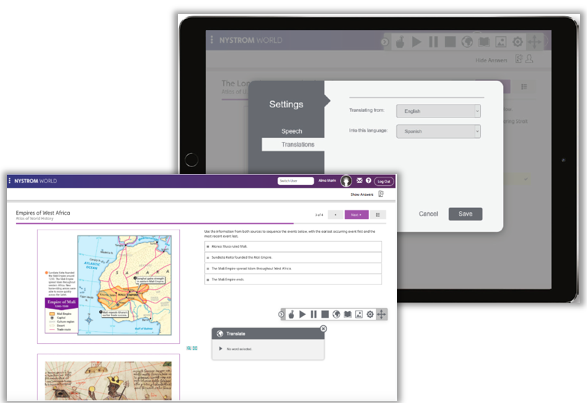
Nystrom World is home to over 100 maps in a variety of subjects and skill levels. Each map can optionally display political features, physical features, cities, and borders. Maps are an essential tool for helping young learners discover how things go together, which helps them be better problem solvers and might lead to more of an interest in STEM.


This is a sample of the maps in The Geographer. Click below to see the complete list.
  • Elementary
  • Maps: Primary: Readiness
  • Maps: Intermediate: Physical
  • Maps: Intermediate: Political
  • U.S. History:1 Native Americans
  • U.S. History:2 Spanish Explorers
  • U.S. History
  • Native Americans
  • Spanish Explorers
  • Explorers
  • The Great Exchange
  • European Settlements
  • Texas
  • Spanish Explorers
  • Western Explorations
  • Trails West
  • War with Mexico
  • Indian Wars
  • Secondary
  • Maps: Intermediate: Physical
  • Maps: Intermediate: Continents and Oceans Thematic
  • Maps: Intermediate: Wealth of Countries Thematic
  • Maps: Secondary: Land Use Thematic
  • Maps: Secondary: Population Thematic
  • World History
  • New Babylonian Empire
  • Roman Empire
  • Maya, Aztec, and Inca
  • World War I
  • World Conflicts Since 1991
Texas_Atlas_Pack_image__1_
Nystrom World

The Researcher

The digital collection of atlases on Nystrom World include up-to-date data and are designed to support a blended classroom. Our atlases encourage students to explore the world's lands and oceans while comparing how topography has been altered through political, physical, and human changes.


The Researcher includes the following atlases
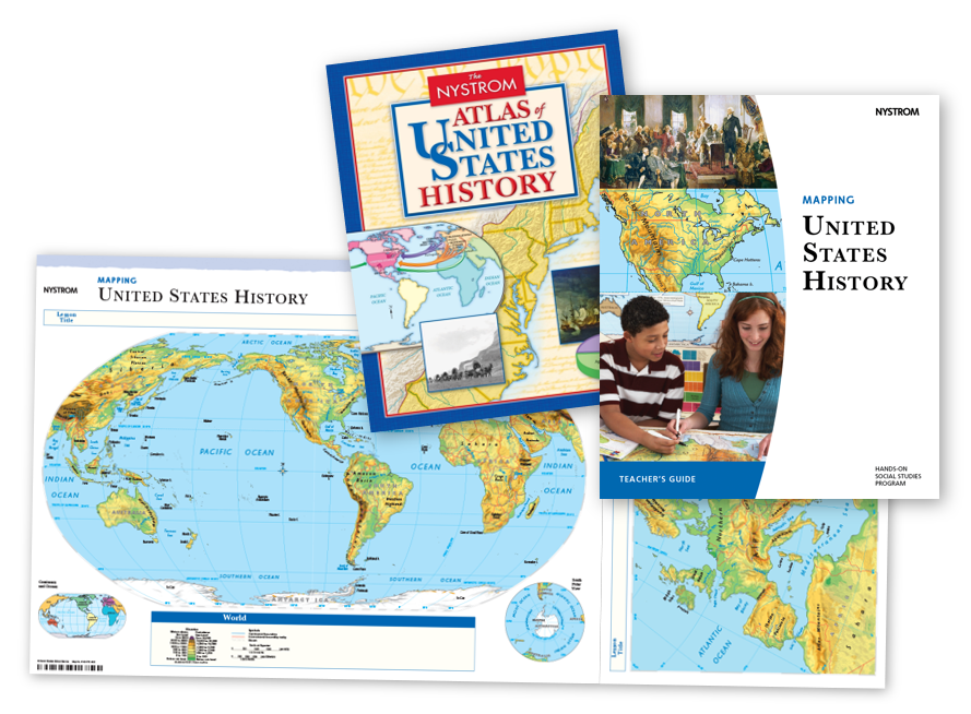
  • Elementary Atlases
  • The Nystrom Jumbo Atlas
  • The Nystrom Block Buddy Atlas
  • The Nystrom Nystronaut Atlas
  • The Nystrom Map Champ Atlas
  • The Nystrom Jr. Geographer Atlas
  • The Nystrom Atlas of our Couintry's History
  • The Nystrom Atlas of New York City
  • Elementary Atlases in Spanish
  • El Atlas de Nystrom Amigos del Barrio
  • El Atlas De Nystrom Mapa Campeones
  • Nystrom Atlas para los Jóvenes Geógrafos
  • El Atlas de Nystrom Gigante
  • El Atlas de Nystrom de la Historia de Nuestro País
  • Secondary Atlases
  • The Nystrom Atlas of United States History
  • The Nystrom Atlas of World History
  • The Nystrom Desk Atlas
  • The Nystrom World Atlas
  • The Nystrom Atlas of Canada and The World
Explorer_img
Nystrom World

The Explorer

Enhance student understanding with powerful mapping programs for secondary classrooms. Engage your students with the help of digitized maps and interactive activities that merge history with geography. Students will analyze data, practice mapping skills, explore primary sources, and improve geographic literacy.


The Explorer includes the following mapping programs
  • Mapping United States History
  • Mapping World History
  • Mapping Our World
FOR GRADES
6
7
8
9
10
11
12
YoungCitizenMG2


Nystrom World

The Scholar

Nystrom World now includes the comprehensive library of K-5 Social Studies Readers. Teachers can mix-and-match readers to create their own library that suits their classroom needs. Each reader includes primary sources from nonfiction photos and contemporary illustrations for students to analyze. Ranging from Level 0 to Level III for most grades, they give all students the opportunity to foster key reading and literacy skills.


FOR GRADES
K-5

Inspire your students to be responsible global citizens by giving them the world!

In the Elementary Classroom

Introduce early learners to the exciting world of maps and atlases with our fun and engaging digital platform. Our collection of digital maps are appropriate for a variety of subjects and skill levels, and our grade-leveled atlases introduce students to complex issues like community, consumerism, and government, in a capacity that they can comprehend. 

In the Secondary Classroom

Comprehensive maps, atlases, and mapping programs provide secondary students with a robust classroom experience. Build map skills, promote geographic literacy, and improve critical thinking with our interactive features that are designed to capture student interest. 

Translation Features

Translation Features with built-in language tools. Housing over 200 languages, students of all language backgrounds can access activities and complete interactive lessons and assessments through this feature. This features helps students with better comprehension and retention of topics and concepts.

Site-Wide Features

All of the features you need are easily accessible from the navigation tool bar. Assign, grade, and monitor your class using one simple dashboard

Meet Standards and Student Needs

Contact us

Elementary

  • Maps: Primary: Early Learning Series
  • Maps: Primary: Readiness
  • Maps: Primary: Outline World Map
  • Maps: Intermediate: Physical
  • Maps: Intermediate: Political
  • Maps: Intermediate: Continents and Oceans Thematic
  • Maps: Intermediate: Wealth of Countries Thematic
  • Maps: Intermediate: Precipitation Thematic
  • Maps: Intermediate: Temperature Thematic
  • Maps: Intermediate: Time Zones Thematic
  • Maps: Intermediate: Land Use Thematic
  • Maps: Intermediate: Population Thematic
  • Maps: Intermediate: Outline World Map
  • U.S. History:1 Native Americans
  • U.S. History:2 Spanish Explorers
  • U.S. History:3 Explorers
  • U.S. History:4 The Great Exchange
  • U.S. History:5 European Settlements
  • U.S. History:6 Thirteen British Colonies
  • U.S. History:7 Slavery In the Americas
  • U.S. History:8 Revolutionary War
  • State Map

Secondary

  • Maps: Intermediate: Physical
  • Maps: Intermediate: Political
  • Maps: Intermediate: Continents and Oceans Thematic
  • Maps: Intermediate: Physical
  • Maps: Intermediate: Political
  • Maps: Intermediate: Continents and Oceans Thematic
  • Maps: Intermediate: Wealth of Countries Thematic
  • Maps: Intermediate: Precipitation Thematic
  • Maps: Intermediate: Temperature Thematic
  • Maps: Intermediate: Time Zones Thematic
  • Maps: Intermediate: Land Use Thematic
  • Maps: Intermediate: Population Thematic
  • Maps: Intermediate: Outline World Map
  • Maps: Secondary: Land Use Thematic
  • Maps: Secondary: Population Thematic
  • Maps: Secondary: Political Relief
  • Maps: Secondary: Land Cover
  • Maps: Secondary: Sculptural Relief
  • Maps: Secondary: Growing Seasons Thematic
  • Maps: Secondary: Climate Thematic
  • Maps: Secondary: Tectonic Plates Thematic
  • Maps: Secondary: Precipitation Thematic
  • Maps: Secondary: Outline World map
  • State Map

US History

  • American Expansion
  • Explorations of the West
  • Trails West
  • War with Mexico
  • Slavery Divides the Nation
  • Slavery and the Economy
  • Union and Confederacy
  • Civil War
  • Conflicts with Indians
  • Railroads Transform the West
  • Industrial United States
  • Immigrants 1895-1929
  • World War I in Europe
  • Great Depression and Dust Bowl
  • World War II in Europe 1939-1942
  • World War II in the Pacific 1941-1970
  • Great Migration 1940-1970
  • Korean War
  • Cold War
  • Vietnam War

World History

  • New Babylonian Empire
  • Ancient Egypt
  • Chinese Dynasties
  • Ancient India
  • Athens and Sparta
  • Alexander’s Empire
  • Roman Empire
  • Barbarians and the Roman Empire
  • Silk Road and Eurasian Trade
  • Byzantine Empire
  • Charlamagne’s Frankish Empire and the Holy Roman Empire
  • Spread of Islam
  • World of the Crusades
  • China in the Middle Ages
  • Mongol Conquests
  • Rise and Fall of Shogun Japan
  • Exploration
  • Maya, Aztec, and Inca
  • European Exploration and Land Claims
  • African Empires and States
  • Rise of Ottoman Empire
  • Reformation and Counter Reformation
  • European Trading Empires
  • Rise and Fall of Mughal Empire
  • Independence in the Americas
  • Napoleon’s Europe
  • Europe After the Congress of Vienna
  • Africa Under Foreign Rula
  • World War I
  • World War II
  • Cold War
  • World Conflicts Since 1991

Elementary

  • Maps: Primary: ELS
  • Maps: Primary: Readiness
  • Maps: Primary: Outline World Map
  • Maps: Intermediate: Physical
  • Maps: Intermediate: Political
  • Maps: Intermediate: Continents and Oceans Thematic
  • Maps: Intermediate: Wealth of Countries Thematic
  • Maps: Intermediate: Precipitation Thematic
  • Maps: Intermediate: Temperature Thematic
  • Maps: Intermediate: Time Zones Thematic
  • Maps: Intermediate: Land Use Thematic
  • Maps: Intermediate: Population Thematic
  • Maps: Intermediate: Outline World Map
  • U.S. History:1 Native Americans
  • U.S. History:2 Spanish Explorers
  • U.S. History:3 Explorers
  • U.S. History:4 The Great Exchange
  • U.S. History:5 European Settlements
  • U.S. History:6 Thirteen Britishi Colonies
  • U.S. History:7 Slevery In the Americas
  • U.S. History:8 Revolutionary War
  • State Map

Secondary

  • Maps: Intermediate: Physical
  • Maps: Intermediate: Political
  • Maps: Intermediate: Continents and Oceans Thematic
  • Maps: Intermediate: Wealth of Countries Thematic
  • Maps: Intermediate: Precipitation Thematic
  • Maps: Intermediate: Temperature Thematic
  • Maps: Intermediate: Time Zones Thematic
  • Maps: Intermediate: Land Use Thematic
  • Maps: Intermediate: Population Thematic
  • Maps: Intermediate: Outline World Map
  • Maps: Secondary: Land Use Thematic
  • Maps: Secondary: Population Thematic
  • Maps: Secondary: Political Relief
  • Maps: Secondary: Land Cover
  • Maps: Secondary: Scupltural Relief
  • Maps: Secondary: Growing Seasons Thematic
  • Maps: Secondary: Climate Thematic
  • Maps: Secondary: Tectonic Plates Thematic
  • Maps: Secondary: Precipitation Thematic
  • Maps: Secondary: Outline World Map
  • State Map

U.S. History

  • Native Americans
  • Spanish Explorers
  • Explorers
  • The Great Exchange
  • European Settlements
  • Thirteen British Colonies
  • Slavery in the Americas
  • Revolutionary War
  • American Expansion
  • Explorations of the West
  • Trails West
  • War with Mexico
  • Slavery Divides the Nation
  • Slavery and the Economy
  • Union and Confederacy
  • Civil War
  • Conflicts with Indians
  • Railroads Tansform the West
  • Industrial United States
  • Immigrants 1895–1929
  • World War I in Europe
  • Great Depression and Dust Bowl
  • World War II in Europe 1939–1942
  • World War II in the Pacific 1941–1945
  • Great Migration 1940–1970
  • Korean War
  • Cold War
  • Vietnam War
  • Persian Gulf War
  • A Shifting Population
  • Immigrants Sinve 1970

World History

  • New Babylonian Empire
  • Ancient Egypt
  • Chinese Dynasties
  • Ancient India
  • Athens and Sparta
  • Alexander’s Empire
  • Roman Empire
  • Barbarians and the Roman Empire
  • Silk Road and Eurasian Trade
  • Byzantine Empire
  • Charlemagne’s Frankish Empire and the Holy Roman Empire
  • Spread of Islam
  • World of the Crusades
  • China in the Middle Ages
  • Mongol Conquest
  • Rise and Fall of Shogun Japan
  • Exploration
  • Maya, Aztec, and Inca
  • European Exploration and Land Claims
  • African Empires and States
  • Rise of Ottoman Empire
  • Reformation and Counter Reformation
  • European Trading Empires
  • Rise and Fall of Mughal Empires
  • Independence in the Americas
  • Napoleon’s Europe
  • Europe After the Congress of Vienna
  • Africa Under Foreign Rule
  • World War I
  • World War II
  • Cold War
  • World Conflicts Since 1991

Texas

  • Spanish Explorers
  • Western Explorations
  • Trails West
  • War with Mexico
  • Indian Wars
  • Railroads & The West
  • Great Migration
  • population Loss and Growth
  • Native Americans in TX
  • Spanish Settlements
  • Republic of Texas
  • Energy Resources of TX
  • Texas Readiness Map
  • Texas Desk Map
  • Texas State Map