Visualizing US history’s what, when, where, how, and why
Deepen Understanding and Reinforce Learning
Students gather, organize, and synthesize evidence from text and visual resources to place milestone events within larger historical trends, visualizing history as they learn content and build skills.
Build Mapping Skills by Analyzing Data
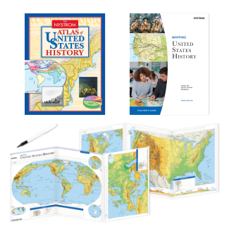
Immerse students in United States history by merging history and geography. Build map skills, cultivate geographic literacy, and enhance critical thinking skills with Nystrom’s Mapping United States History.
A Look Inside
Support your secondary United States history classroom with the newly updated, hands-on Mapping U.S. History series. The program includes a comprehensive student atlas, teacher’s guide, and 15 markable activity maps.
“Incorporating hands-on activities with maps can help students ground themselves in a specific location when discussing geography or history. This forms a connection that is tangible, experiential, and therefore memorable.”
Dr. Aaron P. Willis
Chief Learning Officer, Social Studies School Service
Learn More About Mapping U.S. History
Please fill out the form and a curriculum specialist will be in touch shortly
Elementary
Maps: Primary: ELS
Maps: Primary: Readiness
Maps: Primary: Outline World Map
Maps: Intermediate: Physical
Maps: Intermediate: Political
Maps: Intermediate: Continents and Oceans Thematic
Maps: Intermediate: Wealth of Countries Thematic
Maps: Intermediate: Precipitation Thematic
Maps: Intermediate: Temperature Thematic
Maps: Intermediate: Time Zones Thematic
Maps: Intermediate: Land Use Thematic
Maps: Intermediate: Population Thematic
Maps: Intermediate: Outline World Map
U.S. History:1 Native Americans
U.S. History:2 Spanish Explorers
U.S. History:3 Explorers
U.S. History:4 The Great Exchange
U.S. History:5 European Settlements
U.S. History:6 Thirteen Britishi Colonies
U.S. History:7 Slevery In the Americas
U.S. History:8 Revolutionary War
State Map
Secondary
Maps: Intermediate: Physical
Maps: Intermediate: Political
Maps: Intermediate: Continents and Oceans Thematic
Maps: Intermediate: Wealth of Countries Thematic
Maps: Intermediate: Precipitation Thematic
Maps: Intermediate: Temperature Thematic
Maps: Intermediate: Time Zones Thematic
Maps: Intermediate: Land Use Thematic
Maps: Intermediate: Population Thematic
Maps: Intermediate: Outline World Map
Maps: Secondary: Land Use Thematic
Maps: Secondary: Population Thematic
Maps: Secondary: Political Relief
Maps: Secondary: Land Cover
Maps: Secondary: Scupltural Relief
Maps: Secondary: Growing Seasons Thematic
Maps: Secondary: Climate Thematic
Maps: Secondary: Tectonic Plates Thematic
Maps: Secondary: Precipitation Thematic
Maps: Secondary: Outline World Map
State Map
U.S. History
Native Americans
Spanish Explorers
Explorers
The Great Exchange
European Settlements
Thirteen British Colonies
Slavery in the Americas
Revolutionary War
American Expansion
Explorations of the West
Trails West
War with Mexico
Slavery Divides the Nation
Slavery and the Economy
Union and Confederacy
Civil War
Conflicts with Indians
Railroads Tansform the West
Industrial United States
Immigrants 1895–1929
World War I in Europe
Great Depression and Dust Bowl
World War II in Europe 1939–1942
World War II in the Pacific 1941–1945
Great Migration 1940–1970
Korean War
Cold War
Vietnam War
Persian Gulf War
A Shifting Population
Immigrants Sinve 1970
World History
New Babylonian Empire
Ancient Egypt
Chinese Dynasties
Ancient India
Athens and Sparta
Alexander’s Empire
Roman Empire
Barbarians and the Roman Empire
Silk Road and Eurasian Trade
Byzantine Empire
Charlemagne’s Frankish Empire and the Holy Roman Empire