Encompass: Exploring Texas

Build geographic literacy, background knowledge, and comprehension with an experiential mapping program made Grade 4.

Saddle Up for a Texas-Sized Classroom Adventure!

Hit the trail with Encompass: Exploring Texas, Grade 4 – the experiential mapping program designed just for Texas classrooms. This TEKS-aligned supplementary program isn’t just about reading maps, it’s about discovering the heart and soul of the Lone Star State. From the sweeping plains to the rolling Hill Country, students will dig into Texas’s geography, history, and communities with interactive activities that make learning as big and bold as Texas itself.

Engage, Connect, Assess, and Close

The teacher’s guide is filled with skills-based activities designed around the Exploring Texas atlas and markable geography tools, putting geography at the foundation of social studies. Each activity includes clear objectives and is divided into four sections:

  • Engage & Connect
  • Deliver New Content
  • Show What You Know
  • Close the Lesson
MKTP-NW_G4-3d-TG-spiral-cvr

Build Geographic Literacy and Background Knowledge

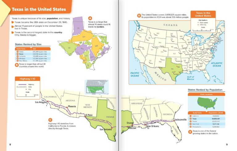
Students engage with text and images using the Exploring Texas atlas, which includes images with captions, chunked text, detailed maps, legends, graphs, and charts. The Grade 4 atlas is scaffolded, meeting students where they are and preparing them for Grade 5. 

Give Students Experiential Learning Opportunities

With the aid of kid-sized globes and desk maps, students practice skills, engage in conversations, and respond to their peers’ ideas. Working in small groups, students interact with age-appropriate primary and secondary sources featured on the Social Studies Place Mats.  

Elementary students using a hands-on map and atlas
MKTP-NW_ENCP-G4 TX-cart

Check It Out Yourself!

With custom-designed Texas maps, globes, and the Exploring Texas Atlas at its core, this program helps students chart their way through the state’s rich past and present. Whether they’re tracing the paths of early settlers or exploring the regions that shaped Texas, your students will develop skills and background knowledge that sticks for years to come.

Download a free sample and see how this program can liven up your classroom faster than a bluebonnet in spring!


Get in Touch

Please fill out the form and we’ll be in touch shortly

Elementary

  • Maps: Primary: ELS
  • Maps: Primary: Readiness
  • Maps: Primary: Outline World Map
  • Maps: Intermediate: Physical
  • Maps: Intermediate: Political
  • Maps: Intermediate: Continents and Oceans Thematic
  • Maps: Intermediate: Wealth of Countries Thematic
  • Maps: Intermediate: Precipitation Thematic
  • Maps: Intermediate: Temperature Thematic
  • Maps: Intermediate: Time Zones Thematic
  • Maps: Intermediate: Land Use Thematic
  • Maps: Intermediate: Population Thematic
  • Maps: Intermediate: Outline World Map
  • U.S. History:1 Native Americans
  • U.S. History:2 Spanish Explorers
  • U.S. History:3 Explorers
  • U.S. History:4 The Great Exchange
  • U.S. History:5 European Settlements
  • U.S. History:6 Thirteen Britishi Colonies
  • U.S. History:7 Slevery In the Americas
  • U.S. History:8 Revolutionary War
  • State Map

Secondary

  • Maps: Intermediate: Physical
  • Maps: Intermediate: Political
  • Maps: Intermediate: Continents and Oceans Thematic
  • Maps: Intermediate: Wealth of Countries Thematic
  • Maps: Intermediate: Precipitation Thematic
  • Maps: Intermediate: Temperature Thematic
  • Maps: Intermediate: Time Zones Thematic
  • Maps: Intermediate: Land Use Thematic
  • Maps: Intermediate: Population Thematic
  • Maps: Intermediate: Outline World Map
  • Maps: Secondary: Land Use Thematic
  • Maps: Secondary: Population Thematic
  • Maps: Secondary: Political Relief
  • Maps: Secondary: Land Cover
  • Maps: Secondary: Scupltural Relief
  • Maps: Secondary: Growing Seasons Thematic
  • Maps: Secondary: Climate Thematic
  • Maps: Secondary: Tectonic Plates Thematic
  • Maps: Secondary: Precipitation Thematic
  • Maps: Secondary: Outline World Map
  • State Map

U.S. History

  • Native Americans
  • Spanish Explorers
  • Explorers
  • The Great Exchange
  • European Settlements
  • Thirteen British Colonies
  • Slavery in the Americas
  • Revolutionary War
  • American Expansion
  • Explorations of the West
  • Trails West
  • War with Mexico
  • Slavery Divides the Nation
  • Slavery and the Economy
  • Union and Confederacy
  • Civil War
  • Conflicts with Indians
  • Railroads Tansform the West
  • Industrial United States
  • Immigrants 1895–1929
  • World War I in Europe
  • Great Depression and Dust Bowl
  • World War II in Europe 1939–1942
  • World War II in the Pacific 1941–1945
  • Great Migration 1940–1970
  • Korean War
  • Cold War
  • Vietnam War
  • Persian Gulf War
  • A Shifting Population
  • Immigrants Sinve 1970

World History

  • New Babylonian Empire
  • Ancient Egypt
  • Chinese Dynasties
  • Ancient India
  • Athens and Sparta
  • Alexander’s Empire
  • Roman Empire
  • Barbarians and the Roman Empire
  • Silk Road and Eurasian Trade
  • Byzantine Empire
  • Charlemagne’s Frankish Empire and the Holy Roman Empire
  • Spread of Islam
  • World of the Crusades
  • China in the Middle Ages
  • Mongol Conquest
  • Rise and Fall of Shogun Japan
  • Exploration
  • Maya, Aztec, and Inca
  • European Exploration and Land Claims
  • African Empires and States
  • Rise of Ottoman Empire
  • Reformation and Counter Reformation
  • European Trading Empires
  • Rise and Fall of Mughal Empires
  • Independence in the Americas
  • Napoleon’s Europe
  • Europe After the Congress of Vienna
  • Africa Under Foreign Rule
  • World War I
  • World War II
  • Cold War
  • World Conflicts Since 1991

Texas

  • Spanish Explorers
  • Western Explorations
  • Trails West
  • War with Mexico
  • Indian Wars
  • Railroads & The West
  • Great Migration
  • population Loss and Growth
  • Native Americans in TX
  • Spanish Settlements
  • Republic of Texas
  • Energy Resources of TX
  • Texas Readiness Map
  • Texas Desk Map
  • Texas State Map