My Account / Cart / Log In

Encompass U.S. Regions

Grade 4 Mapping Program

Hands-On, Activity-Based Program

Teach fourth-graders geography using developmentally appropriate tools and activities!

Discover What's Inside

Encompass U.S. Regions teaches fourth-graders geography through the following topics:

  • Unit 1: How Do We Read Maps and Globes?
  • Unit 2: How Do Maps and Globes Help Us Find Places?
  • Unit 3: How Do Maps Show Political and Physical Features?
  • Unit 4: What Are Different Types of Thematic Maps?
  • Unit 5: What Can We Learn about Regions?
Elementary students working collaboratively to mark up a map

Build Foundational Skills

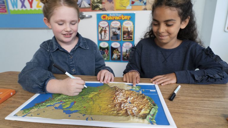
Using hands-on activities, you’ll teach fourth-graders the following foundational skills and concepts:

  • Identifying characteristics of a map and a globe
  • Locating places by using latitude and longitude
  • Understanding physical maps
  • Reading a population map
  • Identifying regions’ physical features and land uses
  • Describing an important aspect of each region

Supplement Social Studies with Turnkey Activities

Encompass is a fun and flexible way to teach geographic literacy. Skills-based activities can be taught sequentially or stand on their own. And at 15–30 minutes, they’re easy to fit into instructional time. 

Each activity includes an assessment and a cross-curricular extension. And we provide answer keys too! Activity Examples: Decoding Maps and Globes, Global Address, Elevation, Population Density

Encompass Grade 4 Sample Activity
Encompass Grade 4: U.S. Regions: Program Components on a Classroom Cart

Get a Cartful of Components

Your students will enjoy working collaboratively with the writable globe, maps, and Place Mat.
  • Encompass U.S. Regions Teacher’s Guide
  • Our Country’s Geography Student Atlas—set of 30
  • 9″ Activity Globe—set of 6
  • U.S./World Political Desk Map—set of 15
  • U.S./World Physical Desk Map—set of 15
  • Social Studies Place Mat—set of 6
  • U.S. Natural Regions Raised Relief Map—set of 6
  • Wet-Erase Markers—set of 30
  • Elementary Atlas Cart
  • Interactive Mapping Activities

Engage Students with Interactive Activities

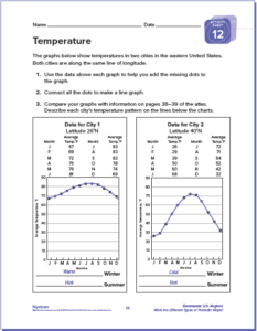
Access the digital version of U.S. Regions at Nystrom World. Interactive mapping activities correspond to the print versions and give fourth-graders practice with multistep problems. A PDF of the teacher’s guide is included.

Get a Free Sample

Please fill out the form and a curriculum specialist will be in touch shortly

Elementary

  • Maps: Primary: ELS
  • Maps: Primary: Readiness
  • Maps: Primary: Outline World Map
  • Maps: Intermediate: Physical
  • Maps: Intermediate: Political
  • Maps: Intermediate: Continents and Oceans Thematic
  • Maps: Intermediate: Wealth of Countries Thematic
  • Maps: Intermediate: Precipitation Thematic
  • Maps: Intermediate: Temperature Thematic
  • Maps: Intermediate: Time Zones Thematic
  • Maps: Intermediate: Land Use Thematic
  • Maps: Intermediate: Population Thematic
  • Maps: Intermediate: Outline World Map
  • U.S. History:1 Native Americans
  • U.S. History:2 Spanish Explorers
  • U.S. History:3 Explorers
  • U.S. History:4 The Great Exchange
  • U.S. History:5 European Settlements
  • U.S. History:6 Thirteen Britishi Colonies
  • U.S. History:7 Slevery In the Americas
  • U.S. History:8 Revolutionary War
  • State Map

Secondary

  • Maps: Intermediate: Physical
  • Maps: Intermediate: Political
  • Maps: Intermediate: Continents and Oceans Thematic
  • Maps: Intermediate: Wealth of Countries Thematic
  • Maps: Intermediate: Precipitation Thematic
  • Maps: Intermediate: Temperature Thematic
  • Maps: Intermediate: Time Zones Thematic
  • Maps: Intermediate: Land Use Thematic
  • Maps: Intermediate: Population Thematic
  • Maps: Intermediate: Outline World Map
  • Maps: Secondary: Land Use Thematic
  • Maps: Secondary: Population Thematic
  • Maps: Secondary: Political Relief
  • Maps: Secondary: Land Cover
  • Maps: Secondary: Scupltural Relief
  • Maps: Secondary: Growing Seasons Thematic
  • Maps: Secondary: Climate Thematic
  • Maps: Secondary: Tectonic Plates Thematic
  • Maps: Secondary: Precipitation Thematic
  • Maps: Secondary: Outline World Map
  • State Map

U.S. History

  • Native Americans
  • Spanish Explorers
  • Explorers
  • The Great Exchange
  • European Settlements
  • Thirteen British Colonies
  • Slavery in the Americas
  • Revolutionary War
  • American Expansion
  • Explorations of the West
  • Trails West
  • War with Mexico
  • Slavery Divides the Nation
  • Slavery and the Economy
  • Union and Confederacy
  • Civil War
  • Conflicts with Indians
  • Railroads Tansform the West
  • Industrial United States
  • Immigrants 1895–1929
  • World War I in Europe
  • Great Depression and Dust Bowl
  • World War II in Europe 1939–1942
  • World War II in the Pacific 1941–1945
  • Great Migration 1940–1970
  • Korean War
  • Cold War
  • Vietnam War
  • Persian Gulf War
  • A Shifting Population
  • Immigrants Sinve 1970

World History

  • New Babylonian Empire
  • Ancient Egypt
  • Chinese Dynasties
  • Ancient India
  • Athens and Sparta
  • Alexander’s Empire
  • Roman Empire
  • Barbarians and the Roman Empire
  • Silk Road and Eurasian Trade
  • Byzantine Empire
  • Charlemagne’s Frankish Empire and the Holy Roman Empire
  • Spread of Islam
  • World of the Crusades
  • China in the Middle Ages
  • Mongol Conquest
  • Rise and Fall of Shogun Japan
  • Exploration
  • Maya, Aztec, and Inca
  • European Exploration and Land Claims
  • African Empires and States
  • Rise of Ottoman Empire
  • Reformation and Counter Reformation
  • European Trading Empires
  • Rise and Fall of Mughal Empires
  • Independence in the Americas
  • Napoleon’s Europe
  • Europe After the Congress of Vienna
  • Africa Under Foreign Rule
  • World War I
  • World War II
  • Cold War
  • World Conflicts Since 1991

Texas

  • Spanish Explorers
  • Western Explorations
  • Trails West
  • War with Mexico
  • Indian Wars
  • Railroads & The West
  • Great Migration
  • population Loss and Growth
  • Native Americans in TX
  • Spanish Settlements
  • Republic of Texas
  • Energy Resources of TX
  • Texas Readiness Map
  • Texas Desk Map
  • Texas State Map