Elementary Atlas Packs

Scaffolded Skills from the Ground Up

Build Geographic Thinking with Atlas Packs

Nystrom Atlas Packs combine investigation, interpretation, and interactive learning in one complete solution. Students use visually rich maps, graphs, and charts to explore geography, history, and current events, while building critical thinking through multistep questions and exposure to multiple perspectives. Atlas Packs support depth of knowledge (DOK) and geographic literacy at every grade level.

Each Atlas Pack includes:

  • 30 student atlases

  • Reproducible student activity book

Everything works together to make teaching seamless and student learning more meaningful.

Nystrom Elementary Atlas Packs are designed to grow with your students, starting with foundational map concepts and gradually introducing more complex geographic thinking. With developmentally appropriate visuals, captions, and guided text, students explore local, national, and world maps at a pace that builds confidence and comprehension.

View a sample here!

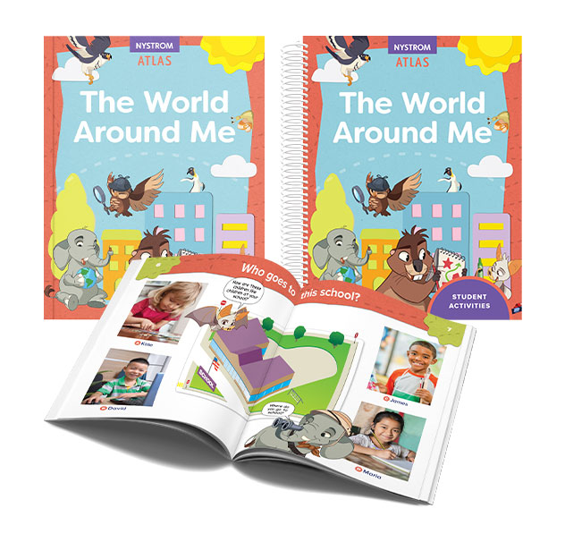
Introduce your kindergartners to geography in fun, age-appropriate ways with the Nystrom World Around Me Atlas. Guided by a cheerful cast of Planet Pals, students explore their families, communities, country, and the wider world—all while building early geographic literacy.

What’s Included:

  • 30 copies of The Nystrom World Around Me Atlas

  • 155-page reproducible Student Activity Book

Features:

  • Bright, engaging visuals and kid-friendly world and U.S. maps

  • Photographs of children around the world

  • Practice with foundational maps and social studies concepts

  • Developmentally appropriate activities that reinforce early geography skills

The Kindergarten Atlas Pack offers a print-based, hands-on experience designed to help your youngest learners make meaningful connections to the world around them.

G1-Elem-Atlas-Pack-ndg

Sample coming soon!

Help your first graders take their next steps in geography with the newly updated Nystrom See the World Atlas. Students learn to read maps and globes, explore where people live and work, and discover how kids around the world are both similar and different.

What’s Included:

  • 30 copies of the Nystrom See the World atlas

  • 141-page reproducible Student Activity Book

Features:

  • Captioned photographs that connect maps to real-life people and places

  • Friendly Backyard Buddies introduce multiple perspectives

  • Age-appropriate maps of neighborhoods, continents, the U.S., and the world

  • ELL-friendly and written at a developmentally appropriate level

The Grade 1 Atlas Pack helps students build core map skills while developing global awareness and foundational social studies understanding—all in a format first graders can explore with confidence.

Watch a video to learn more!

G2-Elem-Atlas-Pack-ndg

Sample coming soon!

Guide your second graders through local and global change with the Nystrom Our Changing World Atlas. Students investigate how communities, environments, and technology evolve, building geographic literacy and a deeper understanding of the world around them.

What’s Included:

  • 30 copies of the Nystrom Our Changing World atlas

  • 140-page reproducible Student Activity Book

Features:

  • Bird Guides help students think about change over time and across places

  • Visuals that connect historical and modern-day maps

  • Accessible maps of the United States, continents, and the world

  • ELL-friendly handouts designed for second-grade learners

The Grade 2 Atlas Pack provides a hands-on, print-based experience that helps students recognize patterns of change and explore how geography connects to their daily lives.

Watch a video to learn more!

G3-Elem-Atlas-Pack-ndg

Sample coming soon!

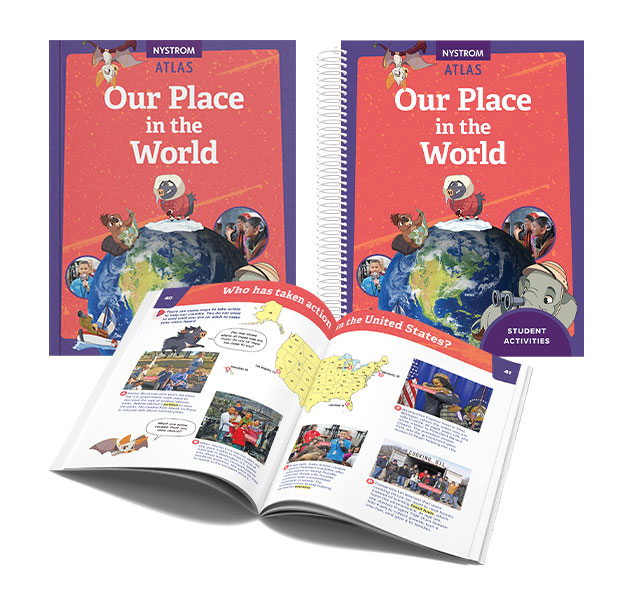
Help your third graders think critically about how communities function—locally and globally—with the Nystrom Our Place in the World Atlas. Students ask questions, explore systems, and consider ways they can take action to improve their communities, their country, and the world.

What’s Included:

  • 30 copies of the Nystrom Our Place in the World atlas

  • 106-page reproducible Student Activity Book

Features:

  • Habitat Helpers ask thought-provoking questions to spark curiosity and reflection

  • Age-appropriate maps of the United States, the world, and continents

  • ELL-friendly handouts written at an accessible level

  • Activities that build geographic literacy, civic understanding, and critical thinking

The Grade 3 Atlas Pack supports students in becoming informed thinkers and active learners, all through a hands-on, print-based approach to geography and social studies.

Watch a video to learn more!

G4-Elem-Atlas-Pack-ndg

Sample coming soon!

Motivate your fourth graders to strengthen their map-reading skills and explore the diverse regions of the United States with the Nystrom Atlas of Our Country’s Geography. Students investigate geographic patterns, environmental features, and technological developments that shape life across the nation.

What’s Included:

  • 30 copies of Nystrom Our Country’s Geography atlas

  • 89-page reproducible Student Activity Book

Features:

  • “Taking Action” pop-outs prompt students to ask meaningful questions

  • Maps of the U.S., world, and continents designed for fourth-grade learners

  • Activities support geographic literacy, critical thinking, and content knowledge

  • ELL-friendly and written at an approachable level

The Grade 4 Atlas Pack helps students deepen their understanding of U.S. geography through hands-on activities and thoughtfully designed visuals—perfect for building skills that last.

Watch a video to learn more!

G5-Elem-Atlas-Pack-ndg

Sample coming soon!

Give your fifth graders a powerful overview of U.S. history with the Nystrom Atlas of Our Country’s History. Students explore major events from 1400 to the present through engaging maps, graphs, and visuals that connect time and place.

What’s Included:

  • 30 copies of the Nystrom Our Country’s History atlas

  • 75-page reproducible Student Activity Book

Features:

  • “Lasting Legacies” highlights the impact of historical events across time

  • Photographs and illustrations deepen understanding and engagement

  • Activities support literacy, content knowledge, and critical thinking

  • Approachable and age-appropriate for fifth-grade learners

The Grade 5 Atlas Pack helps students connect geography and history in meaningful ways, laying the foundation for future learning through hands-on exploration.

Watch a video to learn more!

Chat with your Curriculum Specialist!

Elementary

  • Maps: Primary: ELS
  • Maps: Primary: Readiness
  • Maps: Primary: Outline World Map
  • Maps: Intermediate: Physical
  • Maps: Intermediate: Political
  • Maps: Intermediate: Continents and Oceans Thematic
  • Maps: Intermediate: Wealth of Countries Thematic
  • Maps: Intermediate: Precipitation Thematic
  • Maps: Intermediate: Temperature Thematic
  • Maps: Intermediate: Time Zones Thematic
  • Maps: Intermediate: Land Use Thematic
  • Maps: Intermediate: Population Thematic
  • Maps: Intermediate: Outline World Map
  • U.S. History:1 Native Americans
  • U.S. History:2 Spanish Explorers
  • U.S. History:3 Explorers
  • U.S. History:4 The Great Exchange
  • U.S. History:5 European Settlements
  • U.S. History:6 Thirteen Britishi Colonies
  • U.S. History:7 Slevery In the Americas
  • U.S. History:8 Revolutionary War
  • State Map

Secondary

  • Maps: Intermediate: Physical
  • Maps: Intermediate: Political
  • Maps: Intermediate: Continents and Oceans Thematic
  • Maps: Intermediate: Wealth of Countries Thematic
  • Maps: Intermediate: Precipitation Thematic
  • Maps: Intermediate: Temperature Thematic
  • Maps: Intermediate: Time Zones Thematic
  • Maps: Intermediate: Land Use Thematic
  • Maps: Intermediate: Population Thematic
  • Maps: Intermediate: Outline World Map
  • Maps: Secondary: Land Use Thematic
  • Maps: Secondary: Population Thematic
  • Maps: Secondary: Political Relief
  • Maps: Secondary: Land Cover
  • Maps: Secondary: Scupltural Relief
  • Maps: Secondary: Growing Seasons Thematic
  • Maps: Secondary: Climate Thematic
  • Maps: Secondary: Tectonic Plates Thematic
  • Maps: Secondary: Precipitation Thematic
  • Maps: Secondary: Outline World Map
  • State Map

U.S. History

  • Native Americans
  • Spanish Explorers
  • Explorers
  • The Great Exchange
  • European Settlements
  • Thirteen British Colonies
  • Slavery in the Americas
  • Revolutionary War
  • American Expansion
  • Explorations of the West
  • Trails West
  • War with Mexico
  • Slavery Divides the Nation
  • Slavery and the Economy
  • Union and Confederacy
  • Civil War
  • Conflicts with Indians
  • Railroads Tansform the West
  • Industrial United States
  • Immigrants 1895–1929
  • World War I in Europe
  • Great Depression and Dust Bowl
  • World War II in Europe 1939–1942
  • World War II in the Pacific 1941–1945
  • Great Migration 1940–1970
  • Korean War
  • Cold War
  • Vietnam War
  • Persian Gulf War
  • A Shifting Population
  • Immigrants Sinve 1970

World History

  • New Babylonian Empire
  • Ancient Egypt
  • Chinese Dynasties
  • Ancient India
  • Athens and Sparta
  • Alexander’s Empire
  • Roman Empire
  • Barbarians and the Roman Empire
  • Silk Road and Eurasian Trade
  • Byzantine Empire
  • Charlemagne’s Frankish Empire and the Holy Roman Empire
  • Spread of Islam
  • World of the Crusades
  • China in the Middle Ages
  • Mongol Conquest
  • Rise and Fall of Shogun Japan
  • Exploration
  • Maya, Aztec, and Inca
  • European Exploration and Land Claims
  • African Empires and States
  • Rise of Ottoman Empire
  • Reformation and Counter Reformation
  • European Trading Empires
  • Rise and Fall of Mughal Empires
  • Independence in the Americas
  • Napoleon’s Europe
  • Europe After the Congress of Vienna
  • Africa Under Foreign Rule
  • World War I
  • World War II
  • Cold War
  • World Conflicts Since 1991

Texas

  • Spanish Explorers
  • Western Explorations
  • Trails West
  • War with Mexico
  • Indian Wars
  • Railroads & The West
  • Great Migration
  • population Loss and Growth
  • Native Americans in TX
  • Spanish Settlements
  • Republic of Texas
  • Energy Resources of TX
  • Texas Readiness Map
  • Texas Desk Map
  • Texas State Map