My Account / Cart / Log In

NEW! Encompass

A hands-on elementary mapping program

Bring the power of our new elementary mapping program into your schools. Students will develop and expand their skills and knowledge using a variety of skill-based activities and manipulatives.

MKTP_NW_ENCP_G3_TG_12_13_w_3d_cvr

Supplemental

Supplement your social studies curriculum with Encompass. Activities take 15-30 minutes to teach, making them easy to fit into instructional time.

And they can be taught sequentially or stand on their own, giving teachers choice and flexibility.

_JH_3672

Hands-On

Encompass focuses on hands-on geography, increasing student engagement and retention of knowledge and skills.

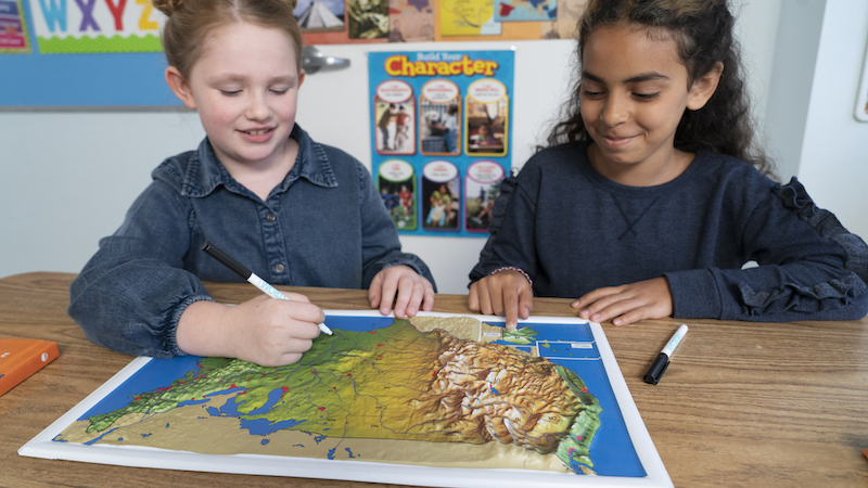
The program includes a variety of markable manipulatives, scaffolded for Grades 1-5.

MKTP_NW_ENCP_G3_Social_Studies_Place_Mat_B

Primary Sources

Encompass includes double-sided social studies Place Mats, designed for group work.

The Place Mats promote primary and secondary source analysis and help students engage with current world issues.

OCWA_g2_ipad

Digital Options

Encompass is also available at Nystrom World as an interactive program. Download a PDF of the teacher's guide and give students practice with multistep problems that lead to depth of knowledge.


A Cartful of Geography Goodies!

Each grade level includes the following durable and engaging components:

  • Teacher’s guide with skill-based activities
  • 30 student atlases
  • 6 markable activity globes
  • 6 markable place mats
  • 6 raised relief desk maps
  • 30 U.S./world desk maps


Grades 1-3 also include 15 community desk maps, and Grade 4 also includes 15 U.S./world political desk maps.

Learning that Sticks!

Encompass builds a variety of hands-on learning experiences into the program to ensure that students

  • actively engage with the content;
  • understand and retain more; and
  • recall and use new information.


Elementary students working collaboratively to mark up a map

Digital Mapping

Encompass is seamless between print and digital. The digital mapping lives at Nystrom World, where teachers can

  • prep for lessons anytime, anywhere;
  • extend learning with interactive activities;
  • monitor student progress from one dashboard; and
  • involve families by giving them frontline access.
NYS087K_GK-Beginnings-TG-cvr-1
Grade K

Beginnings

Kindergartners start learning about their neighborhoods and communities through hands-on geography resources that empower them to understand the world around them.

Components

  • Encompass Beginnings Teacher's Guide
  • The World Around Me Big Book Atlas
  • 30 The World Around Me student atlases
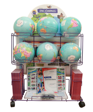
  • 6 9" activity globes
  • 15 community desk maps
  • 6 Social Studies Place Mats
  • 6 raised relief maps
  • 30 wide-tipped markers
  • Elementary Atlas Cart
  • 5-year subscription—coming in 2023!
MKTP_NW_ENCP_G1_TG_cvr
 
Grade 1

Viewpoints

First graders are introduced to geography by identifying symbols, land, and water on a map, and learning about neighborhoods, our country, and the world.

Components

  • Encompass Viewpoints Teacher's Guide
  • 30 See the World student atlases
  • 6 9" activity globe
  • 30 U.S./world desk maps
  • 15 community desk maps
  • 6 Social Studies Place Mats
  • 6 raised relief maps
  • 30 wide-tipped markers
  • Elementary Atlas Cart
  • 5-year subscription—coming in 2023!
MKTP_NW_ENCP_G2_3d_TG_cvr
Grade 2

Changes

Second graders focus on new concepts and topics, such as natural features, community changes over time, U.S. population changes, and protecting our world.

Components

  • Encompass Changes Teacher's Guide
  • 30 Our Changing World student atlases
  • 6 9" activity globe
  • 30 U.S./world desk maps
  • 15 community desk maps
  • 6 Social Studies Place Mats
  • 6 raised relief maps
  • 30 narrow-tipped markers
  • Elementary Atlas Cart
  • 5-year subscription—coming in 2023!
MKTP_NW_ENCP_G3_TG_cvr
Grade 3

Connections

Third graders explore additional concepts and topics, including cardinal directions, latitude and longitude, and taking action in communities, in our country, and around the world.

Components

  • Encompass Connections Teacher's Guide
  • 30 Our Place in the World student atlases
  • 6 9" activity globe
  • 30 U.S./world desk maps
  • 15 community desk maps
  • 6 Social Studies Place Mats
  • 6 raised relief maps
  • 30 narrow-tipped markers
  • Elementary Atlas Cart
  • 5-year subscription—coming in 2023!
MKTP_NW_ENCP_G4_TG_cvr
Grade 4

U.S. Regions

Fourth graders focus even more on geography by decoding maps and exploring physical, political, and thematic maps and studying our country's diverse geographic regions.

Components

  • Encompass U.S. Regions Teacher's Guide
  • 30 Our Country's Geography student atlases
  • 6 9" activity globe
  • 30 U.S./world physical desk maps
  • 15 U.S./world political desk maps
  • 6 Social Studies Place Mats
  • 6 raised relief maps
  • 30 narrow-tipped markers
  • Elementary Atlas Cart
  • 5-year subscription—coming in 2023!
Encompass U.S. History
Grade 5

U.S. History

Fifth graders explore the geographic history of our country, including the time of the first Americans to twentieth-century America and modern America's changing population and technological advances.

Components

  • Encompass U.S. History Teacher's Guide
  • 30 Our Country's History student atlases
  • 6 9" activity globe
  • 30 U.S./world folding desk maps
  • 6 Social Studies Place Mats
  • 6 raised relief maps
  • 30 narrow-tipped markers
  • Elementary Atlas Cart
  • 5-year subscription—coming in 2023!
Image of a quotation mark
“Tell me and I forget, teach me and I may remember, involve me and I learn.”
Benjamin Franklin
 

Get a Free Sample

Please fill out the form and we’ll be in touch shortly

Elementary

  • Maps: Primary: ELS
  • Maps: Primary: Readiness
  • Maps: Primary: Outline World Map
  • Maps: Intermediate: Physical
  • Maps: Intermediate: Political
  • Maps: Intermediate: Continents and Oceans Thematic
  • Maps: Intermediate: Wealth of Countries Thematic
  • Maps: Intermediate: Precipitation Thematic
  • Maps: Intermediate: Temperature Thematic
  • Maps: Intermediate: Time Zones Thematic
  • Maps: Intermediate: Land Use Thematic
  • Maps: Intermediate: Population Thematic
  • Maps: Intermediate: Outline World Map
  • U.S. History:1 Native Americans
  • U.S. History:2 Spanish Explorers
  • U.S. History:3 Explorers
  • U.S. History:4 The Great Exchange
  • U.S. History:5 European Settlements
  • U.S. History:6 Thirteen Britishi Colonies
  • U.S. History:7 Slevery In the Americas
  • U.S. History:8 Revolutionary War
  • State Map

Secondary

  • Maps: Intermediate: Physical
  • Maps: Intermediate: Political
  • Maps: Intermediate: Continents and Oceans Thematic
  • Maps: Intermediate: Wealth of Countries Thematic
  • Maps: Intermediate: Precipitation Thematic
  • Maps: Intermediate: Temperature Thematic
  • Maps: Intermediate: Time Zones Thematic
  • Maps: Intermediate: Land Use Thematic
  • Maps: Intermediate: Population Thematic
  • Maps: Intermediate: Outline World Map
  • Maps: Secondary: Land Use Thematic
  • Maps: Secondary: Population Thematic
  • Maps: Secondary: Political Relief
  • Maps: Secondary: Land Cover
  • Maps: Secondary: Scupltural Relief
  • Maps: Secondary: Growing Seasons Thematic
  • Maps: Secondary: Climate Thematic
  • Maps: Secondary: Tectonic Plates Thematic
  • Maps: Secondary: Precipitation Thematic
  • Maps: Secondary: Outline World Map
  • State Map

U.S. History

  • Native Americans
  • Spanish Explorers
  • Explorers
  • The Great Exchange
  • European Settlements
  • Thirteen British Colonies
  • Slavery in the Americas
  • Revolutionary War
  • American Expansion
  • Explorations of the West
  • Trails West
  • War with Mexico
  • Slavery Divides the Nation
  • Slavery and the Economy
  • Union and Confederacy
  • Civil War
  • Conflicts with Indians
  • Railroads Tansform the West
  • Industrial United States
  • Immigrants 1895–1929
  • World War I in Europe
  • Great Depression and Dust Bowl
  • World War II in Europe 1939–1942
  • World War II in the Pacific 1941–1945
  • Great Migration 1940–1970
  • Korean War
  • Cold War
  • Vietnam War
  • Persian Gulf War
  • A Shifting Population
  • Immigrants Sinve 1970

World History

  • New Babylonian Empire
  • Ancient Egypt
  • Chinese Dynasties
  • Ancient India
  • Athens and Sparta
  • Alexander’s Empire
  • Roman Empire
  • Barbarians and the Roman Empire
  • Silk Road and Eurasian Trade
  • Byzantine Empire
  • Charlemagne’s Frankish Empire and the Holy Roman Empire
  • Spread of Islam
  • World of the Crusades
  • China in the Middle Ages
  • Mongol Conquest
  • Rise and Fall of Shogun Japan
  • Exploration
  • Maya, Aztec, and Inca
  • European Exploration and Land Claims
  • African Empires and States
  • Rise of Ottoman Empire
  • Reformation and Counter Reformation
  • European Trading Empires
  • Rise and Fall of Mughal Empires
  • Independence in the Americas
  • Napoleon’s Europe
  • Europe After the Congress of Vienna
  • Africa Under Foreign Rule
  • World War I
  • World War II
  • Cold War
  • World Conflicts Since 1991

Texas

  • Spanish Explorers
  • Western Explorations
  • Trails West
  • War with Mexico
  • Indian Wars
  • Railroads & The West
  • Great Migration
  • population Loss and Growth
  • Native Americans in TX
  • Spanish Settlements
  • Republic of Texas
  • Energy Resources of TX
  • Texas Readiness Map
  • Texas Desk Map
  • Texas State Map